Carbon sink – conservation management at Munsary, Plantlife’s peatland nature reserve

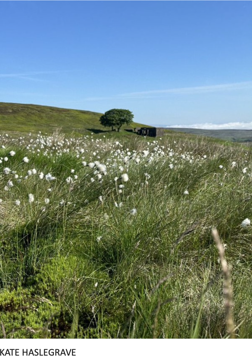
Sunday 27th of July was International Bog Day, and the charity Plantlife re-released a You Tube video from a conference pre the Glasgow COP in 2021, about the peatlands on their reserve at Munsary part of the Flow Country in Sutherland. While this blanket bog may seem a million miles away from Walshaw in its scale and utter remoteness it’s a really good listen, and goes into some depth about peaty science.

Penny Price
Upper Calderdale Wildlife Network

Nick MacKinnon answers the naturally hostile questions put to him by Orlando Jenkinson Windpower Monthly, bible of the wind industry since 1985. 

How has the developer CWF Ltd engaged with the community on the proposals for a wind farm on Walshaw Moor?

Calderdale Wind Farm Ltd (CWF Ltd) has advanced two proposals on Walshaw Moor.


The first proposal was for a 65 turbine 312 MW wind farm, Calderdale Wind Farm (CWF). Engagement with the UK community consisted of a Scoping Report and a website with a number of FAQs. The quality of this engagement can be judged by this FAQ, which was displayed to the public from September 2023 until October 2024.

The embedded capacity register of Electricity North West in fact showed that CWF was not accepted to connect at Padiham, but at much more distant Rochdale. The FAQ also states that the National Grid runs at 440 Kelvin Volts. No reputable wind farm developer makes any of these mistakes. We were dealing with amateurs.

Readers of Windpower Monthly will search in vain for CWF Ltd’s reputation in the field, but if they want to try, the full name of founder and Executive Chairman is Christopher David Griffin Wilson, but they might start in Gibraltar with WWRE Global Ltd.

Wind farm professionals will already be shaking their heads in wonder at the incompetence of CWF Ltd and we are only one FAQ into the first proposal. We cannot give a full account of the collapse of CWF, but readers who follow the links will discover that every statement and map published by CWF Ltd must be checked by the competent public because they are always riddled with mistakes. Even the corrections are wrong. A fairly comprehensive list of CWF Ltd incompetence will be found here.

The initial CWF proposal was withdrawn a fortnight after the FAQ 17 errors (and many others) were pointed out, and the CWF Ltd website was jet-washed of all the damaging mistakes. The campaign has a full set of screenshots, of course. CWF Ltd’s own lead consultant Donald Mackay says of CWF, “It was worse than useless.” Engagement with the community had proved rather bruising for Executive Chairman Christopher Wilson and CWF Ltd.

What happened next?

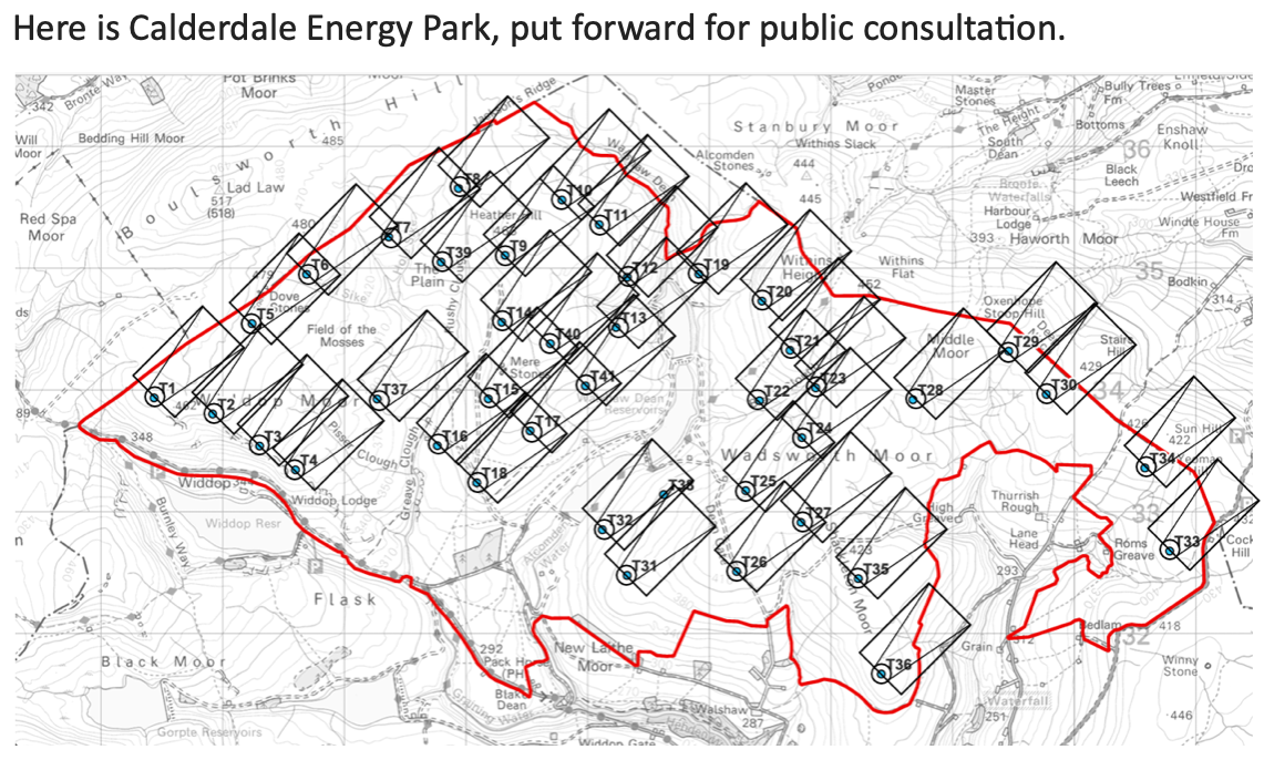
The second proposal on Walshaw Moor is for a 41-turbine wind farm at 302 MW called Calderdale Energy Park (CEP). The public were informed of the “largest wind farm in England” a week before launch with a glossy leaflet in which the layout map was completely blank. The proposal was launched on 29 April at 9 a.m. There was a suite of seven maps showing the layout, peat depths, cultural heritage, access and so on. Every map was wrong in the most comical and revealing way. 

All the maps of the 41-turbine layout showed a T42 and no T38. It was going to be a 42-turbine wind farm, but Project Director Christian Egal had a wobble right at the end of the design meeting (at 16.25 on Friday 21 February 2025) and deleted T38.

T38 had been in row 38 of the six-fig layout spreadsheet. When it was deleted, there was still a T42, now sitting in row 41. This Excel spreadsheet was sent to the map makers, who faithfully made a layout map from the spreadsheet, finishing it on 14 March 2025. 

Project Director and new broom Christian Egal noticed the T42/T38 problem in early April, and new maps were made on 18 April, but nobody loaded them to the website for Launch Day eleven days later and nobody checked.

The blunder was pointed out to CWF Ltd by a member of the public at 9.04 a.m. On 1 May 2025, and a popup correction appeared on the website 86 minutes later. As always with CWF Ltd, the corrections always make their problem worse. 

The statement that “The location of T38 has not been changed” is implausible on the internal evidence and CWF’s own lead consultant didn’t waste any time or personal reputation on the cover-up. “T38 was on the blank section of the peat survey, so we moved it.” Expert readers who look at the CEP layout numbering will see at once how unsustainable this cover-up was. They will again be shaking their heads in amazement both at the errors and the transparently false and pointless cover up. 

This parade of incompetence on Launch Day was of a piece with the previous incompetence of CWF Ltd. Some idea of its full extent will be found here. All this incompetence has been put to CWF Ltd for comment, is in the public domain, and is the subject of legal letters now on file at the Planning Inspectorate.

A second error on the peat depth map scale was also pointed out on 1 May. This was corrected by hand insertion of a sticker into thousands of glossy brochures. “Like schoolboys completing their Italia 90 Panini Albums” said one observer.

Both errors were systemic. They were caused by the failure to complete the peat survey, which could have been done on almost any day between 1 August 2022 and 29 April 2025 for no more than £1000. When the investors have their post-mortem into CWF Ltd, this failure will be high on the list.

Many readers are reputable developers and consultants. In your life have you ever seen such incompetence?

As well as the publication to the British public of seven maps with a T42 on them, CWF Ltd held three events (Oxenhope, Hebden Bridge, Trawden) at places near the boundary of CEP. The behaviour of the consultants at two of these meetings has been widely published. Readers will recognise the consultant-types described. One of them, Donald Mackay, is outstanding, and a fish out of water amid such incompetence. 

The whole “public consultation” (it ran for six weeks) was unlawful under the Gunning Principles, because it was not possible for a member of the public to give ‘intelligent consideration’ to the proposal, which is the legal test. This was principally because the proposal was obviously not a credible wind farm, a fact that will be immediately clear to every reader who looks at the layout map and remembers the rotor diameter is 162 metres. The public could not help but notice other weird errors.

What was wrong with the design process of CEP? 

The primary parameters in a wind farm design are hub height and rotor diameter. A wake of slow moving, turbulent area forms behind a wind turbine and needs to fill with fast air before the next turbine down wind. The turbine spacing is usually 3 RD rows by 5 RD downwind to minimise wake loss in the array without having to buy too much land. If the wind comes powerfully from more than one direction a 5 RD by 5 RD layout might be used, as at Carrick (89 MW Galloway).

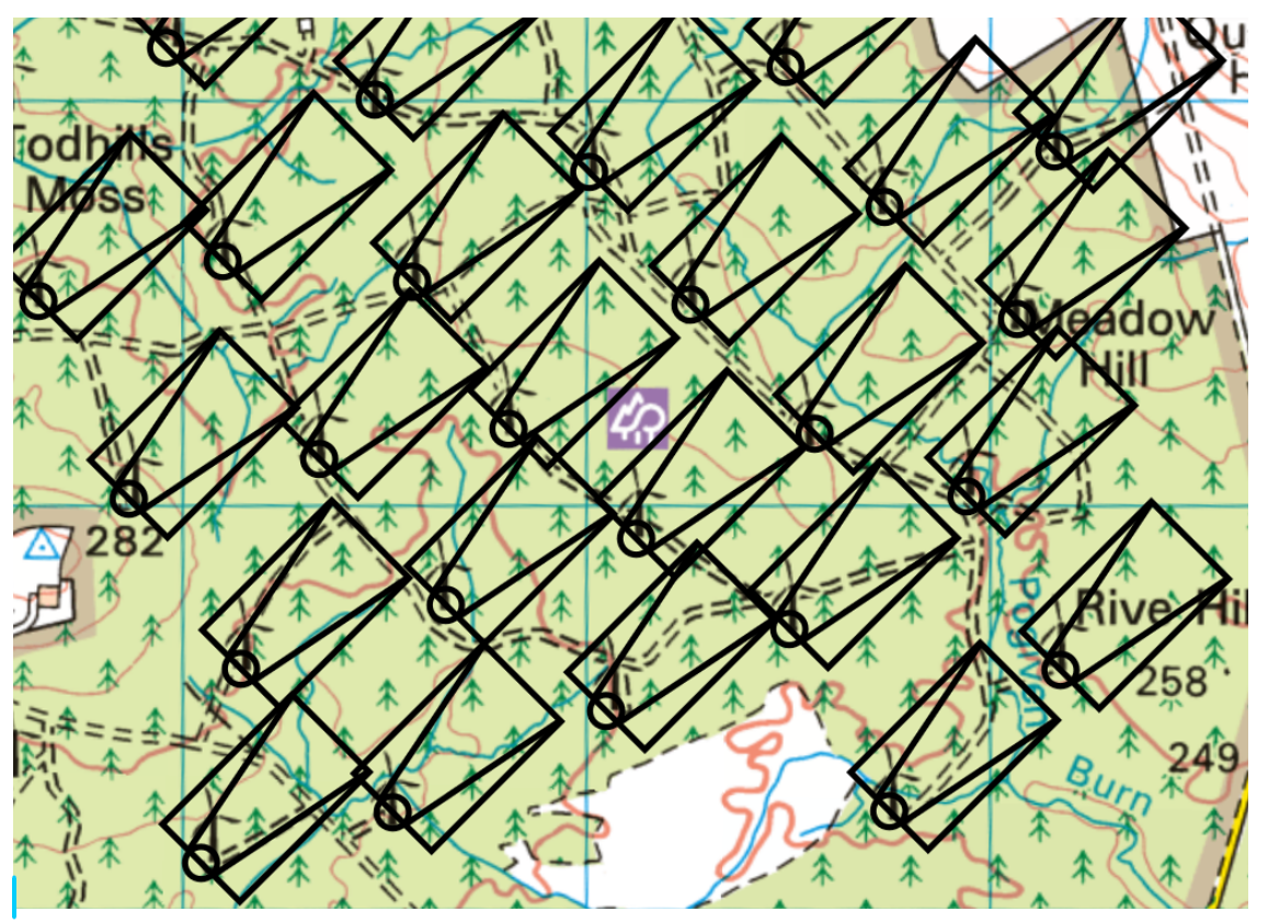
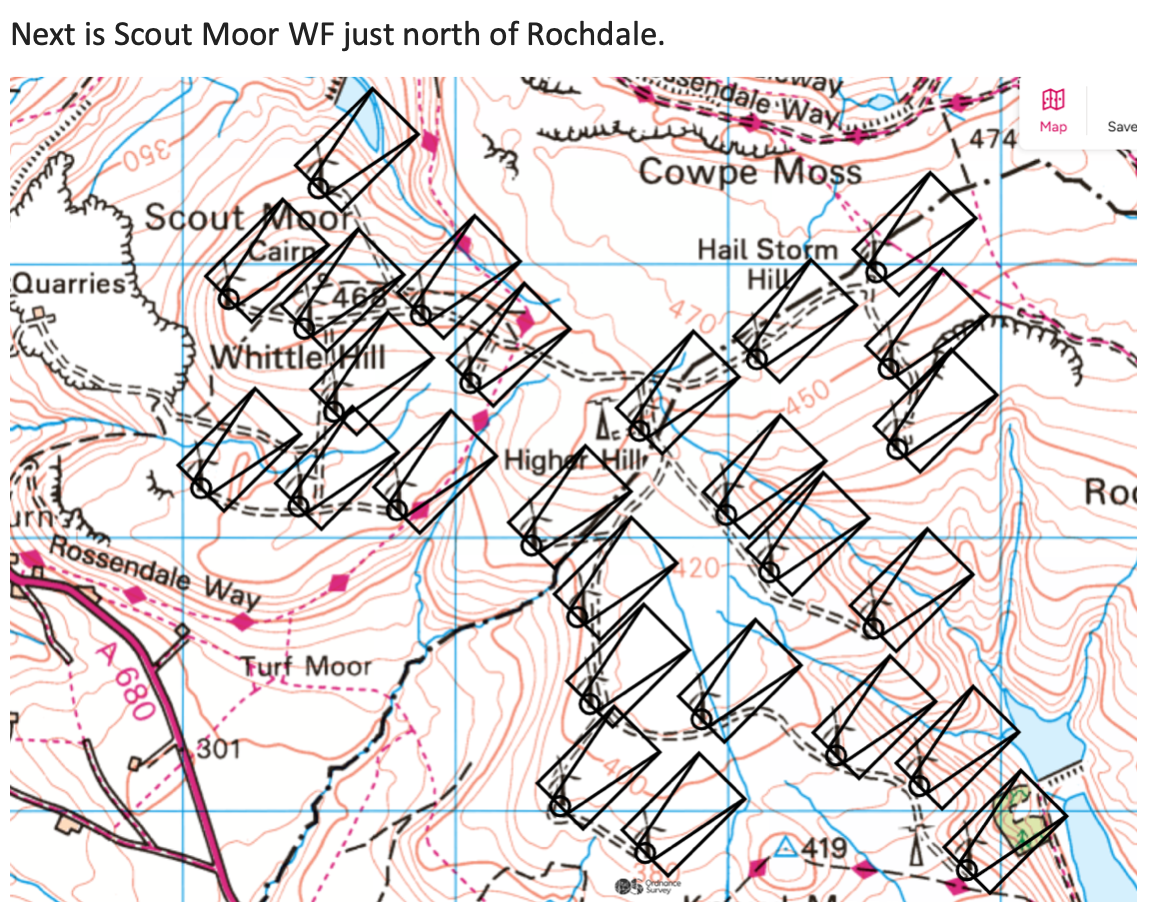
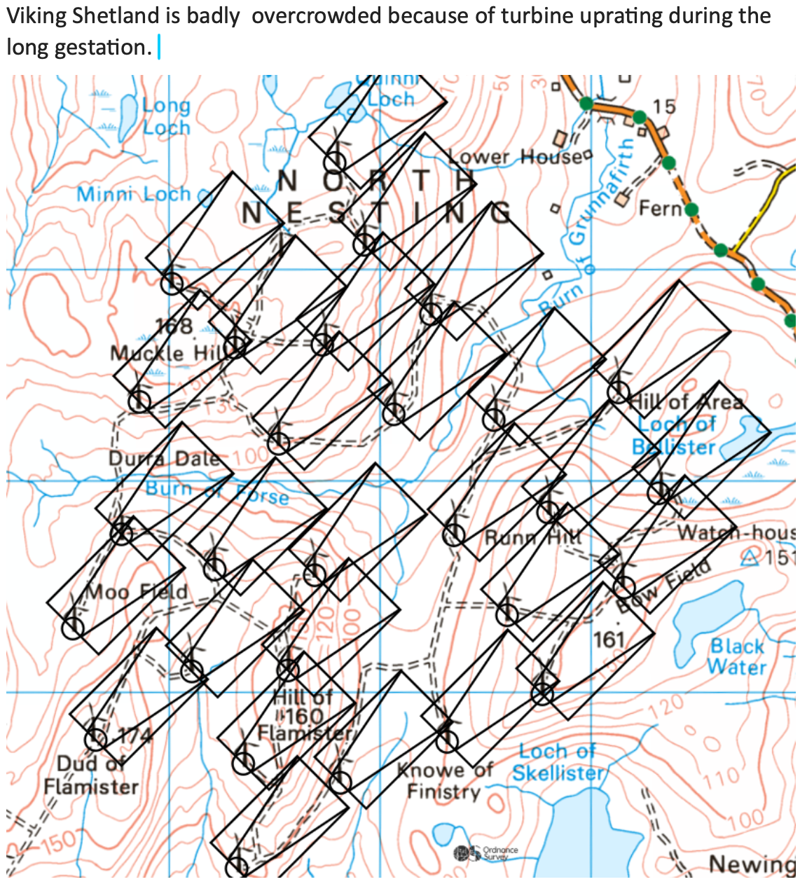
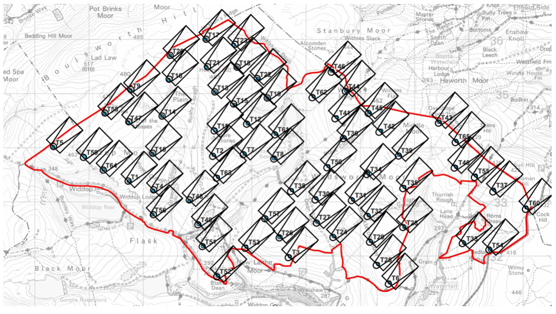
The next four maps show part of Whitelee, Scout Moor, part of Viking Shetland and the collapsed 65-turbine CWF each with the 3 RD by 5 RD footprint in the direction of a SW wind. The spreading lines represent the wake, and the circle is to scale with the swept area of the blades. The first map shows just 10% of the excellent Whitelee 529 MW, south of Glasgow off the M77 

The overcrowding in Viking Shetland is caused by turbine power uprating without resiting during the proposal. It is unsatisfactory, but the national problems with Viking Shetland are more extensive than a slightly overcrowded layout and are an embarrassment to all who care about UK electricity generation, which in the end is every billpayer. The Prime Minister himself has promised to come down hard on these shenanigans which blight the reputation of wind power in the UK. 

Finally here is the competent layout of the original Calderdale Wind Farm 65-turbine proposal. There is loads wrong with this “worse than useless” windfarm, but it started with correct spacing. 

What does the layout of CEP look like? 

It is immediately apparent that CEP is not the result of a reputable design process that began with aerodynamics. It is grossly overcrowded. 

What Project Director Christian Egal and his consultants actually did in the layout meeting on 21 February 2025 has been reconstructed from the maps, admissions made by the consultants at the so-called public exhibitions, admissions made in the CEP Webinar, the sequential numbering, and information passed to us by a mole we call “Deep Stoat”. An account of the design meeting based on this information will be published in August 2025. What the consultants did not do is start with a correct aerodynamic layout, but readers here do not need to be told that.

Since the public cannot give “intelligent consideration” to a proposal that is so far removed from a professionally designed wind farm, the public consultation was unlawful under the Gunning Principles. This point has been made to the CWF Ltd in an exchange of legal letters and the CWF Ltd lawyers have been unable to find arguments to contest the point. Until they do, no lawful public consultation on CEP has taken place. 

Many readers will find the behaviour of CWF Ltd to be a menace to the reputation of all onshore wind in England. 

What concessions, if any, would the campaign be willing to consider or listen to from CWF Ltd? 

 The British public has not been shown a professionally designed wind farm on Walshaw Moor. A necessary condition to anyone giving “intelligent consideration” to CWF Ltd’s proposals is that they should be competent in the first place. We await a lawful public consultation on a professionally designed wind farm, as, surely, does the Planning Inspectorate. We shall need ample time to check all the documents first, and we suggest a six-month buffer before the public consultation so the public can do the necessary field work, given the three-year history of incompetence. 

One member of the campaign has twice offered the investors his help as an expert witness should they want to get some of their money back from Christopher ‘440 Kelvin Volts’ Wilson and CWF Ltd. Britain needs foreign investment, and it is not good for our international reputation to have such comical incompetence on such a famous site. The stepping back of Dr Ghazi Mohammed Osman as person with significant control over CWF Ltd on 19 May 2025 may be the first step in a distancing process that ends in the Chancery Division of the High Court. Nobody with Dr Osman’s stellar reputation wants to become a figure of fun. 

With Dr Osman’s backwards step, Companies House are currently investigating the PSC register of CWF Ltd. Since the company is now interacting with government agencies (Natural England, Planning Inspectorate) the control chain of CWF Ltd should be transparent. CWF Ltd have admitted that the position in the Register represents the actual position.

If the CEP planning process continues, what could CWF Ltd do for the local community that would help improve the situation? 

CEP is an NSIP. The report Unlocking benefits for people, nature and climate: Actions to jointly address climate change and biodiversity loss in England indicates government policy on these national and international matters. Actions for the local community cannot address the national and international problems of CEP.

The local issue that must be addressed is flooding, where CWF Ltd and the Planning Inspectorate would risk corporate manslaughter charges were the published proposal to go ahead.  Walshaw Moor is known to be a dangerous catchment and there have been three severe or catastrophic floods in the Calder Valley since 2000. Because CEP is not professionally designed for aerodynamics, it is also not professionally designed for hydrology.

There is no point discussing hydrology until there is a credible layout to put to the public for intelligent consideration. We note however that the present hydrology map has an enormous error in its mapping of the Greave Clough catchment, caused by a failure to make effective site visits. CWF Ltd have spent £33,000 on ineffective site visits, and they still haven’t discovered the Greave Clough sluice and tunnel.

Why do the proposals for Calderdale Wind Energy Park pose such a danger to ecology? 

Walshaw Moor has international ecology and habitat designations and as we shall see its doubly protected international status now has a world significance under the Kunming-Montreal Framework. 

Walshaw Moor is a Special Area of Conservation for its irreplaceable peatland habitats, and a Special Protection Area for its assemblages of red-listed birds: merlins, golden plovers, curlews and lapwings. These charismatic birds are endangered almost everywhere but thrive on Walshaw Moor. 

The SAC and SPA designations stem from European law (Walshaw Moor is a Natura 2000 site) carried over into British law despite a hard Brexit. The EU was not going to have anything to do with us if we were going to trash the environment. As the Scoping Report for CWF said “The proposal has the potential to cause negative, long-term, international, irreversible degradation and loss to habitats.” 

Walshaw Moor is not a “local moor for local people.” Walshaw Moor has the highest wildlife and habitat designations of any land in the UK. Many professionals will be thinking, “SAC and SPA! What was this Christopher Wilson playing at?” 

There is an even more important matter at stake; the Kunming-Montreal Global Biodiversity Framework. 

Why does the Kunming-Montreal GBF effect Walshaw Moor? 

A clear account is given in “Unlocking benefits…  (July 2025) which makes the government’s position clear on the K-M GBF which we signed (indeed we led) in 2024, as did 190 other nations. We would urge every consultant and wind farm developer to read this report as soon as possible. 

The policy has a forward by the Ministers for Climate Change and Nature at DESNZ and Defra, respectively Kerry McCarthy and Mary Creagh. 

Climate change and biodiversity loss are among the greatest challenges of our time. They are deeply interconnected, and so too must be our response. The United Kingdom, alongside UK Overseas Territories and Crown Dependencies, is committed to delivering ambitious, coherent action that addresses these challenges – because it’s the right choice for today and for future generations. The UK remains steadfast in its commitment to the three ‘Rio’ Conventions that aim to protect the global environment, and to the landmark Paris Agreement and Kunming Montreal Global Biodiversity Framework (GBF).”

The K-M GBF has as its most famous target the 30 by 30 commitment. The report explains what this is. 

The 30 by 30 commitment sits at the very heart of the UK’s aim to ensure nature’s recovery. Delivering this target means ensuring that the most important and wildlife-rich habitats are benefiting from effective, long-term conservation and management. At CBD COP16 in October 2024, the UK confirmed its vision for delivering 30 by 30 in England and published the criteria for land and inland water areas which can count towards this target. At least 7.1% of England’s land has been identified that already meets the 30 by 30 criteria and counts towards the target. This includes Sites of Special Scientific Interest in favourable or unfavourable recovering condition, plus areas of the Public Forest Estate managed for biodiversity. While it is expected that there is additional land already meeting the criteria, such as NGO reserves, this illustrates the scale of action needed to achieve this target. An action plan for 30 by 30 on land is being developed, to ensure this commitment can be achieved. The aim is to finalise and publish this action plan later in 2025.”


The problem for England (conservation is devolved) is that it is one of the most nature-depleted countries on Earth. We talk big about other people’s nature: “Stop eating pangolins! Stop harpooning whales! Stop selling ivory!”) while we relentlessly destroy our own wildlife and habitats. The policy document claims global leadership in conservation but then admits that only 7.1% of England qualifies for our 30% by 2030. The global south already assumes England is hypocritical on nature.

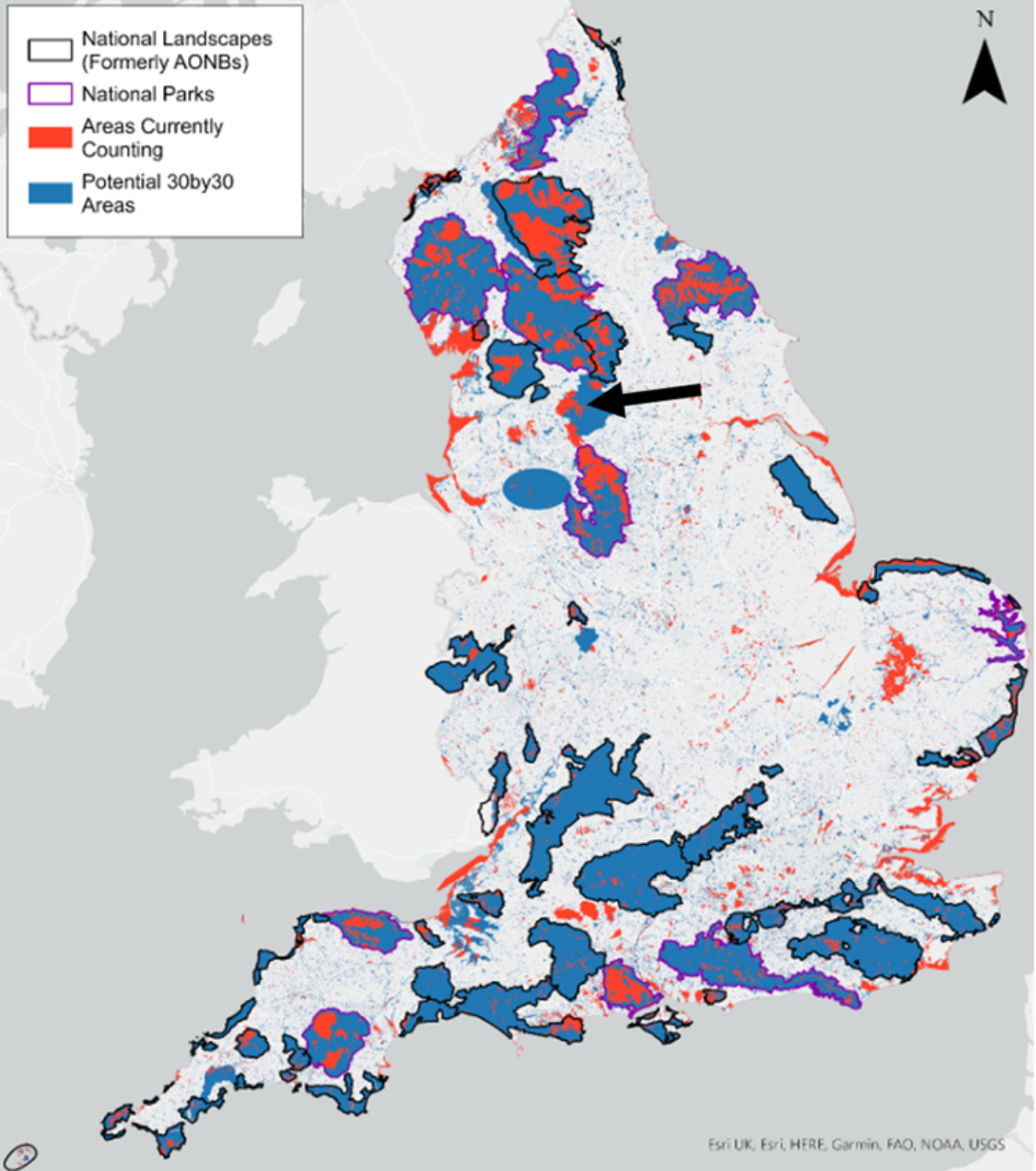
The 7.1% that already meets the criteria is the internationally designated SPAs and SACs and includes Walshaw Moor.  The remaining 23% will be patched together somehow. Defra state that land outside the designations will have to be legally safe from development for at least 20 years.  The problem is made clear in the map below. The red is the 7.1% and of course includes doubly internationally designated Walshaw Moor. The blue needs a huge amount of work. 

If Walshaw Moor, part of the 7.1 % that is meant to be anchoring the policy, can be completely destroyed by a wind farm, just three years after the submission of a comedy Scoping Report that CWF Ltd’s leading consultant says was “worse than useless,” then the whole 30 by 30 plan in England unravels. No land would be legally safe from destruction. We would then have 0% by 2030. 

England does not have pangolins or elephants, and we do not harpoon whales, but we do have outstanding charismatic birds breeding on the irreplaceable peatland habitats of Walshaw Moor, and they do better there than anywhere else in England or Scotland. 

The seriousness cannot be overstated. The Kunming-Montreal GBF international policy, a triumph of British diplomacy, could unravel on Walshaw Moor in 2026. The global south would say, “The English hypocrites couldn’t even keep their hands off their pathetic 7.1%.”

Do you agree that the UK needs more wind energy capacity to meet its climate commitments? 

Nobody knows better than readers of Windpower Monthly that the NESO TEC register already has ten times more wind energy queued up than is required by 2040. The problem is not that we don’t have enough wind generation, but that we don’t know where to build the transmission because the wind farm proposals are all over the shop in a gold rush.

Onshore wind in England is determined by the whims of rich landowners. Onshore wind in England should be NESO-led, not landowner-led. Part of the problem is that the TEC register has failed and speculative projects cluttering it up. Two of these are collapsed Calderdale Wind Farm proposals which should have been removed in October 2024 and are shown below in the latest update. The reference to “CWF 275 kV substation” is to a non-existent facility that might as well be in Narnia.  Here is 482 MW clogging up the TEC register for more reputable projects that readers may be trying to get connected.

[Two CWF Ltd projects clogging up the NESO TEC register with 482 MW of collapsed wind farm. NESO TEC register screenshot: Nick MacKinnon] 

Where should the turbines be built? 

There is a remarkable map, published by Friends of the Earth, who are even more enthusiastic for onshore wind than Windpower Monthly, which shows the vast available area for wind turbines within 5 km of a substation. The Friends map avoids the internationally designated land (Dartmoor, single-designated Exmoor, the Farne Islands and double-designated Walshaw Moor, for example) and the less protected (because only nationally designated) National Parks like the Lake District and the New Forest. The Friends map puts a 2 km buffer around the internationally and nationally designated land and finds that we can have fifty times more wind and solar in the UK than we presently have. There is therefore absolutely no need to tear up our international treaties or build wind farms in the Norfolk Broads. These facts are well-known to all wind farm professionals.


Do you have a response to those who argue that the climate crisis and global heating poses the greatest single threat to ecology in moorland, bogs and peatland like this through e.g. increasing prevalence of wildfires, biodiversity collapse (and that to minimise those things, renewable energy is necessary)? 

Wind farms drain peat and make it more likely to burn. The cheapest thing the UK can do to avert the next climate change tipping point is to rewet our blanket bogs, not dry them out. The tragedy of wind farms (and before that Sitka) on deep Scottish peat must not be repeated in England. The Scottish peat tragedy is what happens if you let the landowners decide where the wind farms are going. We should never again build a wind farm on deep peat. 

Do practices like overgrazing and burning pose threats to this landscape and ecology? 

Burning old heather will soon be forbidden on all deep peat. There is an agreement on Walshaw Moor between the Estate and Natural England, which we pay for, and which runs from 2018 to 2042. The Estate maintain the agreement rigorously. One consequence has been the extraordinary increase in red-listed birds breeding successfully on Walshaw Moor. It is a national wonderland. 

Readers wishing to assess this point should walk a June morning on Walshaw Moor (so much curlew, lapwing and golden plover racket that you can’t hear the skylarks and meadow pipits) and another on high ground  in the Yorkshire Dales National Park, which is almost silent. We need to find out why this is. We are delighted that Windpower Monthly is taking such an interest in the extraordinary ecology on Walshaw Moor. 

The current definition of deep peat in England is 40 cm, but 30 cm will soon be the definition. Calderdale Energy Park will destroy vast areas of deep peat by direct excavation and subsequent drying. The drying effect is much more destructive, as expert readers know. The next tipping point in climate change is when uncontrolled wildfires occur in boreal forests and peat deposits in a ring around the Arctic at our latitude. The UK can have an extraordinarily strong leadership role on this point, because we have a lot of blanket bog. Scotland has begun to wake up to what they have done with their peat. England is already wide awake as government statements on peatland have demonstrated. Thanks to the Scottish tragedy, England will not make the same mistakes.

What about Kate Bush?

Walshaw Moor is one of the most famous pieces of high ground in the world and the inspiration of the Brontë Sisters, themselves three of the most famous women in world history. Nobody over 55 will forget the explosion of Kate Bush onto Top of the Pops on 16 February 1978. We had no idea this was coming!  Hundreds of millions of people know now. 

No government wants us to be a joke abroad. The fame of Walshaw Moor draws people from all over the world who will be astonished to find the UK plans a wind farm above Kate Bush’s Wuthering Heights. They will be even more astonished if the Kunming-Montreal treaty unravels on Walshaw Moor, as will Sir David Attenborough. 

Since the cutting down of the tree in Sycamore Gap, for which the vandals will serve up to four years and three months at His Majesty’s Pleasure, the most iconic sycamores remaining in Britain are the two at Wuthering Heights.

Thank you for helping readers to understand what is happening on Walshaw Moor

It is a pleasure to introduce expert readers, naturally up-to-speed on the technicalities,  to the bog that CWF Ltd have got themselves into. This company had no reputation when it was started, and its present reputation, laid out in these answers to your questions, brings all of UK onshore wind into disrepute. If responsible professionals speak out against CWF Ltd, it will be a positive contribution to the health and future of a vital industry. 

QUICK LINKS
Home
About

Read All About It

Press
Gallery
Privacy Statement
OUR GROUPS

The Boggarts

Calderdale Trades Union Council

Calderdale Windfarm Action Group

For Peat's Sake

Forus Tree

Upper Calderdale Wildlife Network

Walshaw Turbines Research Group

Worth Valley Against Calderdale Wind Farm

Understanding the CEP peat depth survey maps

The peat depth map shown on the CEP website is the fourth one using the same data collected in 2022 by a firm called TNEI. Two young employees probed the peat at 100 metre intervals. “A lad and a lass were sliding about north of Gablestone. Peat’s deep there.”. This data now belongs to CWF Ltd. 

The first map made from this data in 2022 is shown below. 

pastedGraphic.png

The colour scheme of the map makes it hard to follow, and the algorithm used to fill in between the probed points is primitive and deceptive, but this map does tell us some things that the later maps do not. The peat is non-existent on the Pack Horse ridge and on the lowest slopes of Hoar Nib; no CEP turbines are proposed for either area. The bump on the right is no longer inside the wind farm boundary. The probing was done to at least 6 metre on the yellow. . 

The algorithm used to fill in between the probe positions was “Inverse square weighting”.  This is a primitive method that takes an average of the twelve nearest probed depths with further away depths having much less weight in the averaging.  Double the distance; a quarter of the weight. 

The physical act of probing is exhausting once the depth is more than a metre. At three metres you need a weightlifter’s squat lift to get the probe back out again. Greater depths are very time consuming indeed. When we look at the next two maps we will see a blank area that is not present on this first map. The blank area is highly significant and the depths shown on this TNEI map in the blank area are fictional. The algorithm has used depths from far away to fill in a big gap in the data. For some reason the young employees were not allowed to finish the job. Nothing sinister: just incompetence by the management. 

The second map made using the same data was published in the September 2023 Scoping Report for the original 65-turbine Calderdale Wind Farm (CWF)

pastedGraphic_1.png

This map looks very different but uses exactly the same data as the purple map. Natural Power are a highly respected firm of consultants. The map shows the probing positions, including the ones taken in the hump on the right which is no longer inside the boundary. The Kringing algorithm has been used to fill in between the probing cross depths. This method is expensive in computing time and makes optimal use of the data. Because Natural Power are a respected firm, they have not hidden the fact that the algorithm is unable to produce interpolated depths where the peat survey had not been completed. The blank area by T14 is caused by the failure to complete the survey. The Kriging algorithm has a setting that tells it when to give up: and Natural Power had it turned on. If the data isn’t good enough, a blank is printed. 

We cannot use the purple map to fill in the blank section, because the depths in the purple map over the blank area are completely fictional and based on very distant probing. This is what makes the purple map so deceptive. 

The author has probed the peat on Walshaw Moor in many places using a 3 metre avalanche pole, tending to probe where the tracks are going. In some places the depth found has not agreed with the interpolated depth by a full colour difference, but the picture shown in the map seems broadly correct. Below is near Dean Stones with Professor Mike Fox and Dr Mariacarmen Tapia of University of Santiago di Compostela with just over a metre of depth. Note how long the probe is. 

pastedGraphic_2.png

NICK MACKINNON


In the photo the 3 metre probe is buried to the hilt where the Brontë skyline meets the Walshaw Moor Plateau. The peat here is completely intact with no groughs or hags. Chris Goddard ran in snow along here to get to White Swamp. 

pastedGraphic_3.png

NICK MACKINNON

pastedGraphic_4.png

CHRIS GODDARD

CWF Ltd made a cardinal error now. The depth of “deep peat” in England is 0.4 metres or more  (and may soon be 0.3 metres following a Defra consultation). In Scotland the definition is 0.5 metres or more, and the consultants, based in Castle Douglas in Galloway, used 0.5 metres as the cut-off between dark green (< 0.5 m) and light green (0.5 m – 1 m). The blank area (which could have been surveyed in a morning for less than £1000) and the 0.5 m depth area were to cause the huge embarrassments for CWF Ltd on the Launch Day of Calderdale Energy Park. 

The damage done to peat by building a wind farm on Walshaw Moor happens in two ways. One is in the direct digging of foundation holes and road trenches. The excavated peat is done for because its structure is lost. The more extensive damage happens over time. All the wind farm infrastructure has drainage ditches, and these drains dry out the peat in a wide margin around the infrastructure. A 50 metre margin is assumed even by CWF Ltd in their maps of access tracks over off-site peat (Option A  over Oxenhope Moor and Option B over Sandy Hill Moor). The margin can be much larger; it depends on the slope. 

The point to understand is that the main damage to peat is done by drainage over decades and the tracks are where most of the damage happens. The turbine layouts we have been shown for CEP (which are utterly faulty in aerodynamics) do not show the worst peat damage that will occur, which is either side of  the tracks. 

If the peat is less than one metre deep, a six-metre wide trench is cut down to the ‘competent ground’ which on Walshaw Moor is usually yellowish boulder clay spread like butter on the flat sandstone by the last glacier. This trench is filled with “bulk fill” quarried in West Yorkshire, but the top 40 cm has to be a hard roadstone and this will have to be imported to the site. Limestone is not suitable because it is a blanket bog poison. Granite is used at Ovenden Moor WF. It looks like the ballast used in railway construction. 

If the depth is more than one metre the amount of materials to fill the trench, and the amount of spoil peat to be disposed of, becomes uneconomic. Now a floating road is built directly on the peat surface. These have to be as light as possible, so only the hard roadstone is used. 

Neither the cut nor floating track should be at an angle to the contours. The track either goes straight up the slope or runs along watersheds. Other angles risk peat slides, and the risk is exceptional at the north of the site, where a vast bog burst exploded in 1824. Normal wind farms have a maximum gradient on the spine tracks of 10% with 12% on spurs. The CEP layout is incompetent and requires a 21% gradient to get up Option B access and a 26% gradient to get down to T22. 

It is not possible to build an economic wind farm on Walshaw Moor using only the watersheds. The system track structure is a spine track running along watersheds, with spurs dropping down to the edges, trying to cram as many turbines as possible onto the peat. The spurs tracks inevitably drain the watershed peat, and act as storm drains in heavy rain, raising the flood risk. The effect is most evident on Heather Hill, which is grossly overcrowded. 

Returning to the blank area, the diagram below shows how poor the 2022 survey was here. 

pastedGraphic_5.png

Inside the red boundary we have very little idea of what the peat depth is. The Kriging algorithm is guessing the depths from very few crosses and eventually gives up. 

Now we look at the third peat depth map, published by CWF Ltd on 29 April 2025. 

pastedGraphic_6.png

Although Natural Power has their logo on this map, they were unaware of it when I rang them in May 2025 to ask about the various glaring errors. There is a T42 just south of the middle reservoir dam and no T38, which would be expected between T37 and T39, exactly on the blank area. The scale is wrong. Dark green is now < 0.4 metres and light green is 0.5 – 1 metre, but this leaves a gap between 0.4 metres and 0.5 metres. The incompetence which caused these remarkable errors will be described later. The author told CWF Ltd about their incompetence at 09.06, 1 May 2025, and corrections were published at 10:30 the same day (T38/T42)  and a couple of days later (0.4-0.5).

This map is less honest than the Scoping Report map because it does not show the probing crosses. Without the earlier map, we would not know what had caused the blank section or how extensive the problem was. The same data has been used, but this time the cut-off on the dark green area is 0.4 metres, the correct definition of deep peat in England. 

The current version of this map on the CEP website is shown below. The T38/T42 error has been corrected and so, clumsily,  has the key. 

pastedGraphic_7.png

“Please note: a typographical error has been identified in the key on the Peat Depths Map published as part of the non-statutory consultation documents. The interpolated peat depth (m) band 0.5 – 1 should be labelled 0.4 – 1. There are no changes to details on the map itself and the map represents a worst case scenario based on the surveys undertaken to date. Further peat work is ongoing. “

There are several things wrong about this correction. The error was not “typographical”. It was a systemic consequence of the original failure to use the English definition of “deep peat”. Further peat work was not “ongoing” because it was the ground -nesting bird season and peat surveying would have been a criminal act. The map does not represent a “worst case scenario”. It represents the peat depths found by two youngsters in 2022 on a 100 metre grid, interpolated using an industry-leading algorithm that refused to cover up the probing failure. 

The correction was too late for the printed Consultation Brochures, and stickers had to be inserted by hand. “Like schoolboys doing their Italia 90 Panini albums” said one observer.”

To get maximum information out of the four peat depth maps we need to use them together. It is important not to overstate the deficiencies in the Peat Depth maps. All of them are infinitely superior to the Defra “AI-enabled” peat map of England which is irrelevant to any detailed discussion of Walshaw Moor. 

The 3M/T42 problem was caused by the blank on the peat map. The layout of a 42-turbine CEP had been completed at the design meeting on Friday 21 February 2025 when it was noticed that 3M was on the blank area of the peat survey. 

pastedGraphic_8.png

T38 was deleted from the design meeting layout map and row 38 was deleted from the Excel spreadsheet of six-figure turbine locations. T42 now sat in row 41 of the spreadsheet. The layout spreadsheet was saved as 210225-41t and this spreadsheet was sent to the cartographers JWO and LF (not known to Natural Power) who faithfully prepared seven maps of the faulty layout on 14 March 2025. These faulty maps were loaded to the CEP website. In early April the T38/T42 error was noticed and fresh maps were prepared on 14 April 2025, but these were not loaded to the website and nobody checked. 

At 0906 on 1 May 2025 Nick MacKinnon told Tom Andres of Cavendish Consulting that they had a problem and he had better ring Project Director Christian Egal and Executive Chairman Christopher ‘440 Kelvin Volts’ Wilson to find out what to do. 

At 1030 the right maps were loaded and this correction popup still appears on the website. 

pastedGraphic_9.png

The statement “The location of T38 has not been changed” is untrue, does not stand up to the internal evidence and has been explicitly denied by CWF Ltd consultant Donald Mackay, who said, “T38 was on the blank section of the peat map, so we moved it.” CWF Ltd has zero employees. Everybody is a self-employed consultant. The loyalty of all the CWF Ltd consultants has to be to their own businesses first. Donald Mackay goes further. A native of one of the most morally upright societies on Earth, Donald Mackay does not tell lies for Christopher Wilson.

CWF Ltd say these errors are typos, but if they are not important indications of their own misgivings about their proposal, why did they print this childlike lie about T38? As ever, the cover up is always worse than the original mistake. 

© Nick MacKinnon WTRG

QUICK LINKS
Home
About

Read All About It

Press
Gallery
Privacy Statement
OUR GROUPS

The Boggarts

Calderdale Trades Union Council

Calderdale Windfarm Action Group

For Peat's Sake

Forus Tree

Upper Calderdale Wildlife Network

Walshaw Turbines Research Group

Worth Valley Against Calderdale Wind Farm

Will Calderdale Energy Park cause a repeat of the 1824 Bog Burst? 

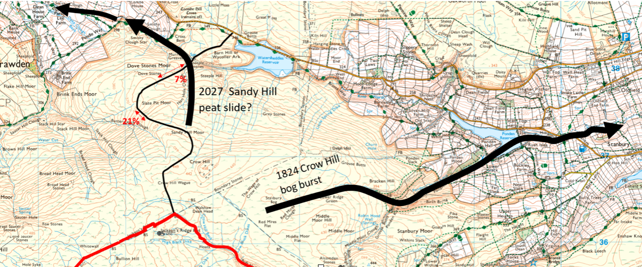
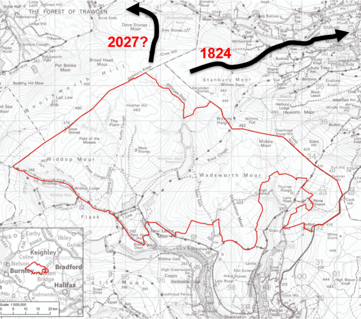
The path of the 1824 bog burst from Stanbury Bog into Ponden Clough. The river of peat and boulders was up to five metres deep and was eventually ten kilometres long. The potential for a similar huge peat slide from the Sandy Moor section of the Option B access road to Calderdale Energy Park is shown. Thousands of 30-tonne tippers carrying crushed stone must come up this zig-zag track, followed by hundreds of abnormal loads of between 100 and 300 tonnes. The sideways traverse across the convex slope of Sandy Hill Moor is the most dangerous thing a track on deep peat can do. Off-piste skiers are killed every year in avalanches caused by their own weight as they traverse convex slopes like this. Map: WTRG
The site of Calderdale Energy Park between Burnley and Bradford. Map: WTRG On 2 September 1824, in a powerful rainstorm, Stanbury Bog burst, and a vast river of peat, water and boulders accelerated down Ponden Clough and charged past Ponden Hall. This blog will show in photographs the track of the 1824 bog burst. Anne (4) and Emily Brontë (6) had walked five miles from home when the bog exploded with such force that the bang was heard in Leeds. Their father Patrick heard it in Haworth and had to see out the storm at the Parsonage, not knowing if his young children would return from the moor with their helpers Nancy and Sarah Gerrs. Reverend Brontë based his next sermon in Haworth on this earthquake. “A rapid torrent of mud and water issued forth, varying from twenty to thirty yards in width and four to five in depth; which, in its course for six or seven miles, entirely threw down or made breaches in several stone and wooden bridges – uprooted trees – laid prostrate walls – and gave many other awful proofs, that, in the hand of Omnipotence, it was an irresistible instrument to execute his justice. Sometimes, God produces earthquakes as awful monitors to turn sinners from the error of their ways, and as solemn forerunners of that last and greatest day, when the universal frame of nature shall tremble, and break and dissolve.”
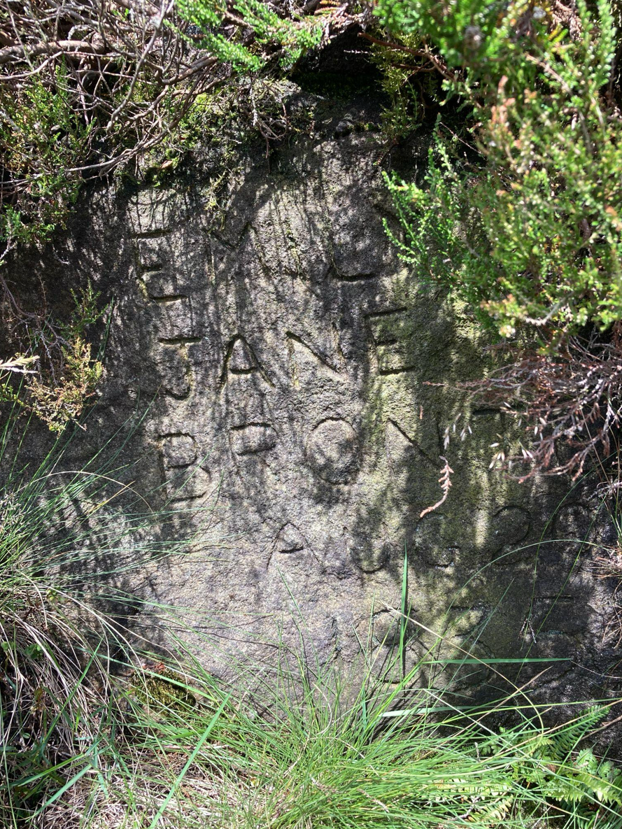
Hidden away near Ponden Kirk in the path of the Bog Burst is this carving: Emily Jane Brontë, August 20. 1835. Photo: John Page
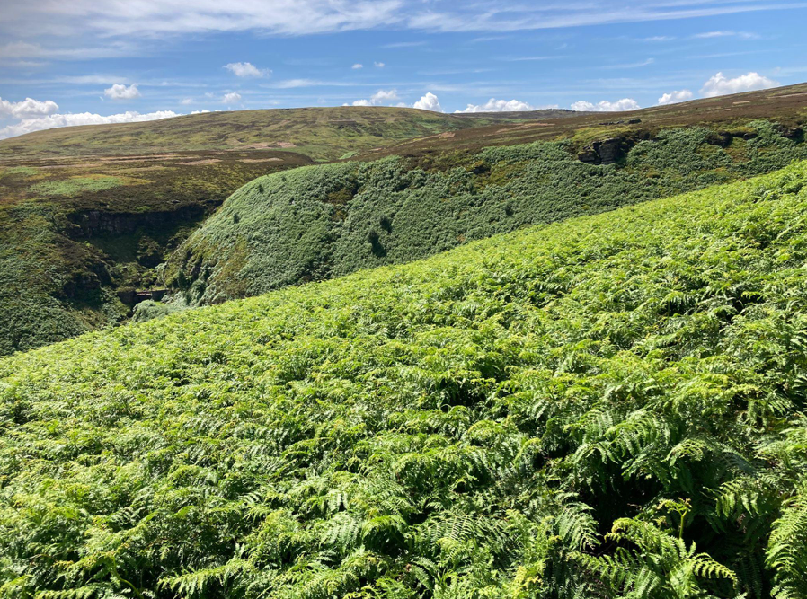
Ponden Kirk is the rock buttress on the right. Raven Rock is on the bend in the Ponden Clough Beck on the left. The 1824 Bog Burst poured into this very steep natural amphitheatre and accelerated. Photo: John Page
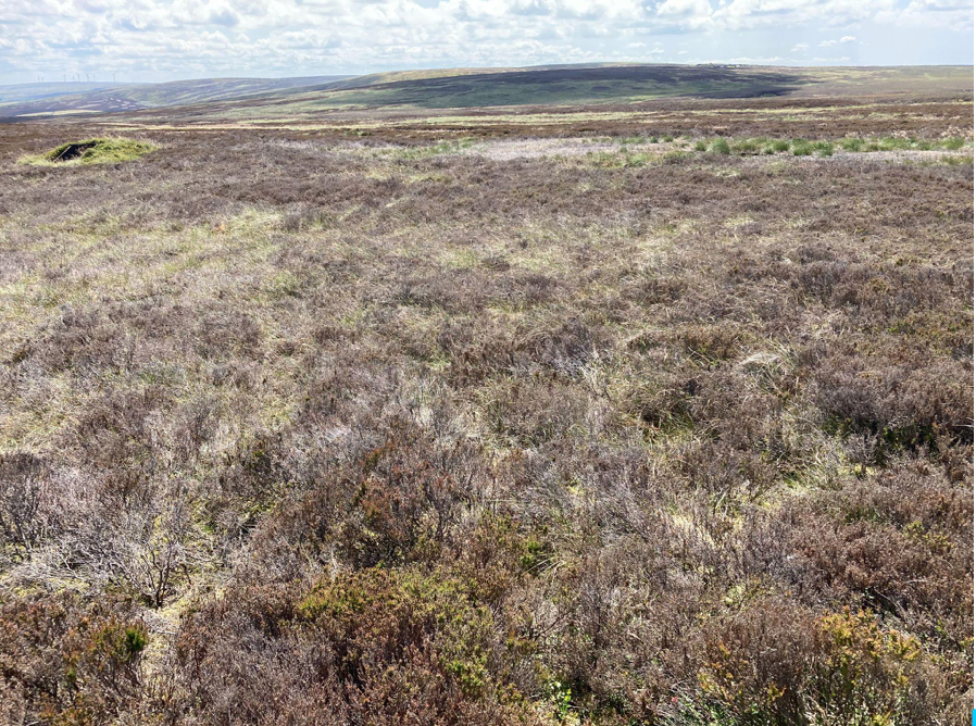
The source of the bog burst. Looking south-east across Stanbury Bog towards Alcomden Stones on the horizon. This is exactly the same terrain that is at the top of Sandy Hill Moor. Photo: John Page
In 2025 we have had the driest Spring on record, and despite the Walshaw Moor Estate’s drainage schemes, Stanbury Bog still lives up to its name. It remains highly unstable and no paths have been established by walkers. Photo: John Page
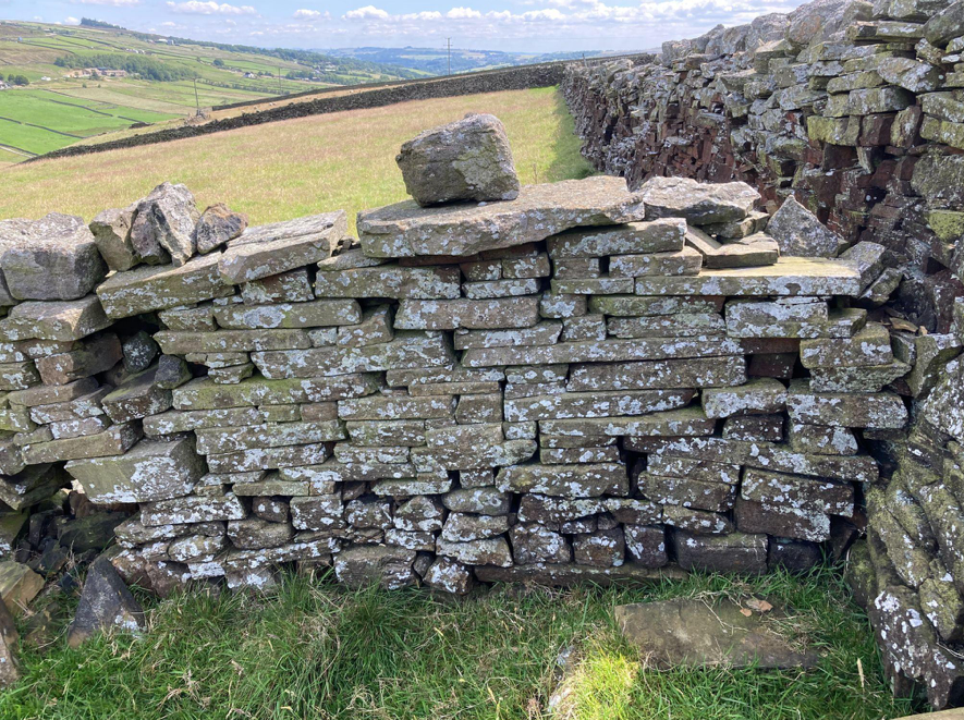
The local geology is sedimentary, laid down in a shallow sea over 300 million years ago. It is in flat layers, like this like this wall. The wet and heavy peat has formed on top of the flat rock. The dividing line between the peat and the bed-rock sandstone is the shear plane and when it breaks on a convex slope the peat accelerates rapidly, and the terrain focuses the tidal wave into a wall of peat, water and boulders. Photo John Page

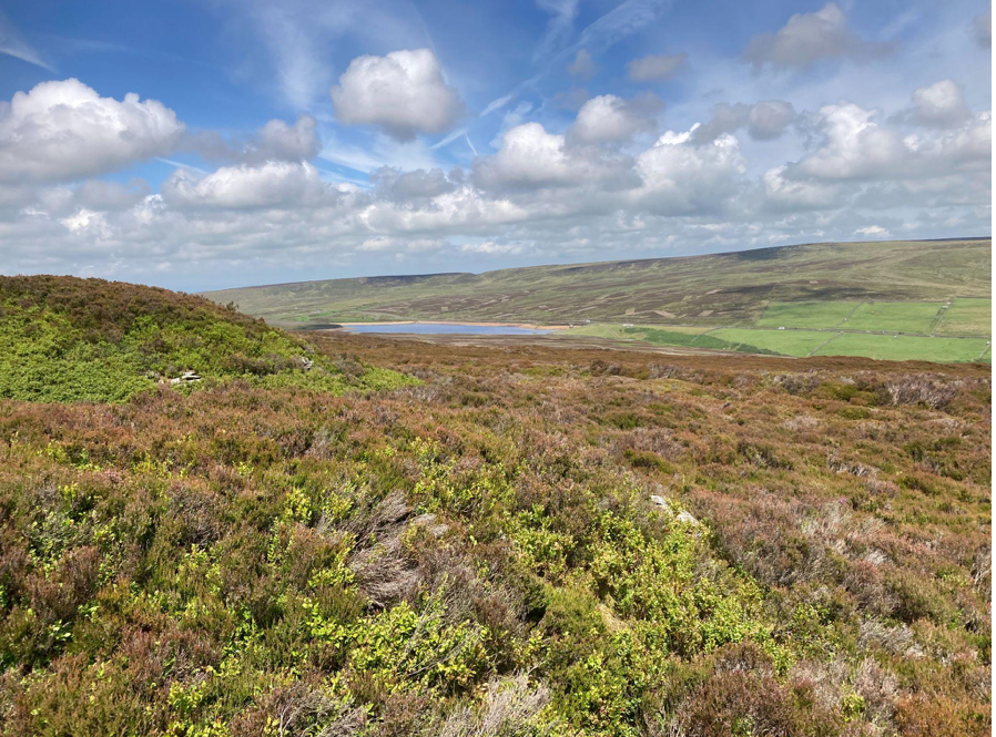
Looking across to Watersheddles Reservoir, from the edge of Middle Moor Flat over the possible route of the 1824 mudslide. Photo John Page

The torrent was up to five metres deep and large boulders were picked up and hurled through the air. The devastation can still be seen on the cratered moors today. For weeks afterwards, the Worth was full of dead fish. Ann Dinsdale, Principal Curator at the Brontë Parsonage Museum, narrates a short film of the event.


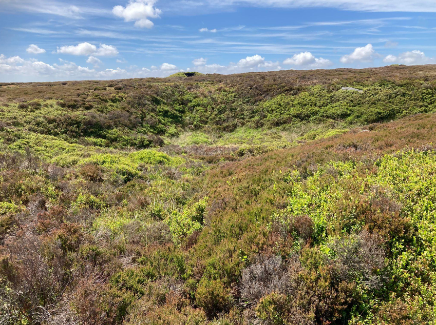
An 1824 Bog Burst crater. Photo: John Page

This huge boulder was carried here in the bog burst. Photo: John Page

The following year in 1825 The Edinburgh Journal of Science published an academic article by David Brewster : Notice of the Rare Atmospheric Phenomenon 1824 in which reference is made to the bog burst.

“Reports from Kelso, Berwick, Belford, Newcastle, and many places in Yorkshire and Northumberland, give accounts of a most alarming storm of thunder and lightning having occurred, accompanied with a’ vast quantity of rain, and spreading destruction over a great extent of the country.—Many men and domestic animals were killed by the lightning. It was during this storm that the subterraneous bog burst at Keighley in Yorkshire, which may be traced to the vast torrents of rain that seem to have accompanied the contemporaneous storm.”

Prior to the bog burst a period of high temperatures and dry conditions were followed by several days of exceptionally heavy rain. This would have led to a very large build-up of water in a dry Stanbury Bog, creating extremely unstable conditions in the deep peat overlaying the sedimentary bedrock. A slippery shear plane formed between the contrasting peat and sandstone, causing the the deep peat to slide down the convex slope. The mudslide would flow north-easterly under gravity into the steep sided valley of the Ponden Clough Beck. Fortunately there was no reservoir in 1824, for the force of the bog burst would have destroyed the dam, adding the reservoir’s water to a murderous torrent heading for Haworth.

Bog bursts are not uncommon. A lot of academic research has been done in recent years on them, and they are often caused by wind farm construction. The Irish Peatland Conservation Council wrote this:

“Bog bursts” or peat flows are a dramatic form of peat erosion. Sections of peat on sloped areas can break off from the main body of a blanket bog and flow down-slope, similar to a volcanic lava flow. Bog bursts usually happen after heavy rain on sites which have been put under human pressures, such as overgrazing, turf cutting or wind farm construction. For example, the construction of a wind farm at Derry Brien, county Galway resulted in a large bog burst causing almost half a square km of blanket bog to travel 2.5 km (Lindsay and Bragg, 2005). During a bog burst it is thought that the living plant layer of the bog tears due to stress and the very wet peat centre flows under the influence of gravity. Other bog bursts have been recorded in Ben Gorm in Connemara, on Clare Island in Co. Mayo and 52 separate bog bursts were recorded at Pollatomish, Co. Mayo”.

Film was taken of a small peat slide on relatively flat ground, caused by construction of Viking WF on Shetland.

Given that CWF Ltd presented such an unfinished proposal at their public consultation, we can have no confidence at all that any thought has gone into the potential for catastrophic peat slides on the north side of CEP.

The crest of the convex slope where Stanbury Bog begins to get steeper, dropping down into the Worth Valley. The boulder is not a glacial erratic, but was brought by the bog burst. Photo: John Page This history and geology of the 1824 bog burst is crucial for CEP because there are exactly the same geomorphological conditions to the north of Crow Hill Wague, in the catchment of the headwaters of the unnamed streams which flow down to Watersheddles Reservoir. This is where the Option B new road would go. A repeat of the September 1824 bog burst towards the top of the convex Sandy Hill Moor slope would wash away the new road, and fan out over Steeple Hill to clog up the small gorge leading into Watersheddles Reservoir, and Nan Hole Clough. If the bog burst were to follow the Nan Hole Clough valley then Wycoller could be destroyed.
These hummocks and groughs on the crest between Stanbury Bog and Bracken Hill are evidence of current instability in the peat mass. Photo: John Page © JOHN PAGE (WTRG)